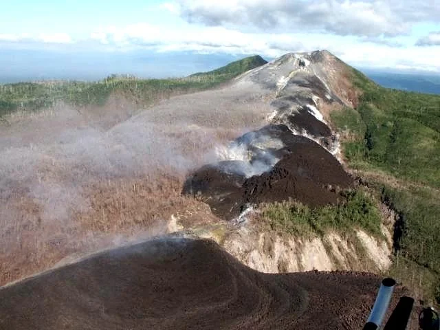
Overview and Tectonic Setting
Witori is a caldera volcano situated in Papua New Guinea at latitude -5.5745 and longitude 150.5161, with a summit elevation of 724 meters. The volcanic structure sits in a subduction zone setting on thick continental crust exceeding 25 kilometers. According to records maintained by the Smithsonian Global Volcanism Program, Witori has a documented history of 19 confirmed eruptions spanning prehistoric and modern eras.
Eruptive History and Explosivity
Witori's eruptive history ranges from prehistoric large-scale explosive events to modern observed eruptions. Out of the 19 confirmed eruptions in the official record, 13 have assigned ratings on the Volcanic Explosivity Index (VEI). The volcano's peak magnitude recorded in the historical archive reached VEI 6.0 during an eruption around 710 CE.
The temporal distribution of confirmed eruptions shows activity extending from the 76th century BCE to the 21st century CE:
- Prehistoric Era (BCE): Single confirmed eruptions recorded in the 76th century BCE (around 7510 BCE ± 150 years), 40th century BCE, 14th century BCE, and 7th century BCE.
- Early Common Era (CE): Eruptions recorded in the 4th century CE (around 310 CE, VEI 5.0), 7th century CE (around 710 CE, VEI 6.0), 8th century CE, 10th century CE, and 11th century CE.
- Later Historical Era: Eruptions documented in the 15th century CE (around 1450 CE), 16th century CE, and two events in the 18th century CE.
- Modern Era: Three confirmed eruptions during the 20th century CE and three during the 21st century CE.
Representative Eruption Records
Historical dates and magnitudes are determined using a variety of geological evidence methods, including isotopic radiocarbon dating, tephrochronology correlation, and direct visual reporting. The table below outlines representative records from the volcano's eruption history archive.
| Start Date | End Date | Activity Area | VEI | Evidence Method |
|---|---|---|---|---|
| 7510 BCE (±150 yrs) | — | Witori | Unassigned | Isotopic: 14C (uncalibrated) |
| 310 CE (±100 yrs) | — | Unspecified | 5.0 | Isotopic: 14C (calibrated) |
| 710 CE (±75 yrs) | — | Unspecified | 6.0 | Isotopic: 14C (uncalibrated) |
| 1450 CE (?) | — | Unspecified | Unassigned | Correlation: Tephrochronology |
| May 3, 2012 | July 11, 2012 | Pago | 2.0 | Observations: Reported |
Latest Confirmed Eruption
The most recent confirmed eruption associated with the Witori volcanic system occurred at the Pago activity area. The event began on May 3, 2012, and concluded on July 11, 2012. It was documented through direct observational reporting and reached a magnitude rating of VEI 2.0.
Frequently asked questions
Where is Witori located?
Witori is a caldera volcano located in Papua New Guinea at latitude -5.5745 and longitude 150.5161, with a summit elevation of 724 meters.
How many confirmed eruptions are recorded for Witori?
There are 19 confirmed recorded eruptions for Witori documented in the Smithsonian Global Volcanism Program database, dating from 7510 BCE to 2012 CE.
What is the largest recorded magnitude for a Witori eruption?
Witori's largest recorded eruption reached a Volcanic Explosivity Index (VEI) rating of 6.0, dated to around 710 CE.
When was Witori's most recent eruption?
The latest confirmed eruption at Witori occurred at the Pago activity area between May 3, 2012, and July 11, 2012, reaching a VEI of 2.0.
Image credits
- Elliot Endo — Wikimedia Commons source — Public domain
Sources and further context
Official datasets support the event-specific facts.